|
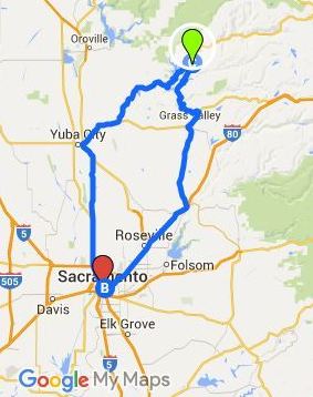
There are two main ways to get to camp from Sacramento. One uses I-80 and goes through Auburn, the other uses CA-99 and goes through Marysville. Both take approximately the same amount of time, however some choose the Marysville route because it is a less windy trip.
Please feel free to use a GPS to get you to Camptonville. The directions from Highway 49 to camp are not correct for all GPS's and the electronic directions can be confusing if you are unfamiliar with Camp Pendola or direct you to a one lane mountain road. Narrative directions are listed below USE THE FOLLOWING DIRECTIONS FROM CAMPTONVILLE!Continue on Highway 49 for another 3 1/2 miles - DO NOT TAKE PENDOLA ROAD!!! (please check your odometer) Take the road to your left, it is called Pendola Extension Road (3 1/2 miles past the Camptonville turnoff). Follow this road for 4 miles, remaining on the blacktop. Two further signs will direct you to Pendola Center. This last section is on gravel road. The total distance from Highway 49 to Pendola Center is about 5 1/2 miles. YA ESTANDO EN CAMPTONVILLE, ¡¡¡USE LA SIGUIENTES DIRECCIONES!!! Continúe por la Carretera 49 por unas 3 ½ millas - ¡¡¡NO TOME LA SALIDA PARA LA CALLE PENDOLA!!! (utilice su odómetro) Desvíese por la calle que le saldrá a su izquierda, ésta calle se llama “Pendola Extension Road” (está a 3 ½ millas después de la salida de Camptonville) Continúe por esta calle por 4 millas más, manteniéndose en el pavimento. Saldrán dos letreros más que le dirigirán hacia el Centro Pendola. Esta última sección es una carretera de grava. La distancia total de la Carretera 49 al Centro Pendola es de 5 ½ millas. |
|
Via-I-80 from Sacramento
Take I-80 east to Auburn. Exit to to the right ontp Highway 49, Grass Valley turnoff. This exit will take you under the freeway. Follow Highway 49 to Grass Valley and Nevada City, a distance of about 28 miles. At Nevada city, Highway 49 makes a left turn; TAKE THIS TURN, following the sign which says "Downieville." After driving for 16 miles, you will pass through North San Juan. Another 8 miles and you will be a t the Camptonville turnoff. Use the directions "Direction from Camptonvile" at the top of this page. From Redding
Take Highway 99 south to Chico. Take highway 70 to Oroville. Take the Oro Dam BLVD. exit. Turn left on Oro Dam Blvd. Go through Oroville. Turn right onto Highway 162 (Olive Highway). Turn right onto Miners Ranch Road. Turn left on Bangor Highway--this changes to Los Verjeles Road. When Los Verjeles ends, turn left onto Loma Rica Road. Turn left at Marysville Road. Marysville Road will turn into Willow Glen Road--turn right at this point to stay on Marysville Road (follow the signs to Bullards Bar Reservoir). Go through Dobbins and cross the dam at Bullards Bar Reservoir. At Highway 49 turn left. Watch for a sign on your right which says "Historic Camptonville." Follow the directions at the top of this page for directions from Camptonville. |
From Marysville
Take Highway 20 east toward Grass Valley. After about 10 miles, turn left at the Chevron Gas Station onto Marysville Road. Marysville Road will turn into Willow Glen Road--turn right at this point to stay on Marysville Road (follow the signs to Bullards Bar Reservoir). Go through Dobbins and cross the dam at Bullards Bar Reservoir. At Highway 49 turn left. Watch for a sign on your right which says "Historic Camptonville." Follow the directions at the top of this page for directions from Camptonville. From Reno
Take I-80 west to Yuba Gap taking Highway 20 to Nevada city. As you enter Nevada City, Highway 49 makes a right turn; TAKE THIS TURN, following the sign which says "Downieville." After driving for 16 miles, you will pass through North San Juan. Another 8 miles and you will be a t the Camptonville turnoff. Use the directions "Direction from Camptonvile" at the top of this page. |

